
The remains of a Mayan city have been discovered deep in a Mexican jungle thanks to new age laser scanning.
The Archeology Council of the National Institute of Anthropology and History found the city named ‘Ocomtun’, which means ‘stone column’ in the Yucatec Maya language - in March of this year.
The agency said they had stumbled across remains while searching a less-explored stretch of the Balamku ecological reserve on Mexico's Yucatan Peninsula.
Advert
Scientists discovered stone columns, the ruins of pyramid-like buildings, three plazas and other ancient structures they believe date back to 600 and 900 AD.
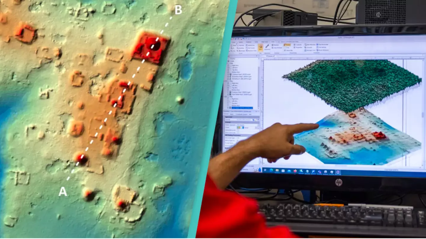
Juan Carlos Fernandez-Diaz, an assistant professor in civil engineering at the University of Houston, spotted the city while sweeping the area, as per CNN.
Fernandez-Diaz is a trailblazer in Light Detection and Ranging (LiDAR) imagery - airborne light detection and ranging equipment that can find ancient structures.
Advert
“When we see the (LiDAR) images, we can see that there’s something amazing [but] the real discovery happens after a lot of investigation and exploration,” said Fernandez-Diaz.
The project, led by archeologist Ivan Sprajc, revealed that scientists undertook a 37-mile journey through the dense vegetation surrounding the lost city.

"The biggest surprise turned out to be the site located on a 'peninsula' on high ground, surrounded by extensive wetlands," Ṡprajc said in a statement.
Advert
"Its monumental nucleus covers more than 50 hectares and has various large buildings, including several pyramidal structures over 15 meters [50 feet] high.
He added: “It’s a bit like mowing the lawn — going one direction turning around in a parallel direction and repeating that back and forth to get the coverage we want."
While scientists had their work cut down for them, remote sensing technology made it more accessible to explore densely forested areas.
And because of this new age technology, it has proved to be a gold mine for locating ancient cities, especially ones deep in the jungle.
Advert
With LiDAR, sensors track the time each laser pulse takes to return, which helps to create a three-dimensional map of structures lying beneath.
“The simplest analogy is like playing tennis, you know, you basically throw a ball to the wall and see the ball come back and basically measure the time it (takes to go) to the wall and come back. And because it’s a laser, it’s traveling at the speed of light,” Fernandez-Diaz said, as per CNN.
Topics: News, Science, Technology, World News